
By: Natasha Archary
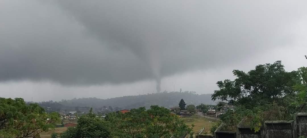
A tornado has ripped through Inanda, KwaZulu-Natal on Tuesday, 27 June, tearing through a number of homes and damaging infrastructure.
Two people have since been hospitalised after sustaining minor injuries.
According to storm chaser, and SA weather show host, The Weather Hooligan, the tornado was confirmed by several weather services and experts.
Although efforts were made to warn people of the tornado, The Weather Hooligan says because the weather is so unpredictable, any predictions made about the tornado’s path or touchdown were pre-emptive.
Opinion from Gianluca de Gasparis, an Amateur Weather Enthusiast, points to a number of complex reasons behind the rare and destructive weather phenonmenon.
“This afternoons tornado in inanda KZN was very interesting for a number of reasons.
Wind profiles were and are supportive of a marginal severe threat however the CAPE (convective available potential energy) levels, while high for this time of year (at just over a 100kj/100kg) are completely insufficient, that compined with cool surface temperatures and dew points seemed to negate any potential threat for severe weather.
However, at around 12:00 local time satellite imagery revealed a complex of updrafts froming along the coast from Port Shepstone northwards towards Durban.
By 14:00 one of these updrafts matured into a weak low topped supercell thunderstorm, somewhat reminicent of the “cold core” tornado events in the US.
This storm slowly moved northeast while producting at least one weak torndao which damaged informal settlements in the Suburb of inanda. I await weather balloon data from King Shaka International Airport as well as more photos and videos to draw a more thourough conclusion.”
Also read: IPID investigates death of metro cop who was allegedly gunned down by SAPS officer
![[WATCH PODCAST] Mr. Mercedes drops highly anticipated project, joining forces with Thabo Smol and Spice Drums](https://www.kaya959.co.za/wp-content/uploads/2026/10/KAYA-959-THUMBNAILS-79-1170x658.png)
![[WATCH PODCAST] Tumisho Masha commands the screen as colonel Jack Phatudi in M-Net’s new must-watch series](https://www.kaya959.co.za/wp-content/uploads/2026/10/KAYA-959-THUMBNAILS-78-1170x658.png)
![[WATCH PODCAST] Mr. Mercedes drops highly anticipated project, joining forces with Thabo Smol and Spice Drums](https://www.kaya959.co.za/wp-content/uploads/2026/10/KAYA-959-THUMBNAILS-79-100x100.png)
![[WATCH PODCAST] Tumisho Masha commands the screen as colonel Jack Phatudi in M-Net’s new must-watch series](https://www.kaya959.co.za/wp-content/uploads/2026/10/KAYA-959-THUMBNAILS-78-100x100.png)